Episode 075
A Ski-Packraft-Tramping Expedition from Mt Aspiring to Waiatoto with Nick Pascoe

Episode 075
A Ski-Packraft-Tramping Expedition from Mt Aspiring to Waiatoto with Nick Pascoe
Spotify Apple Podcasts Everywhere else Download
I'll admit I'm no mountaineer, and I've never done anything on ice. So this one blew my mind a little bit, in the best way.
Nick lives in Wānaka, grew up in the South Island, works in product design and calls himself a bit of a jack-of-all-trades adventurer. A few years ago, standing on top of Mount Aspiring, he looked straight down the Waiatoto River to the Tasman Sea and saw a route. So he and two mates pieced it together: skis and packrafts on their backs, from French Ridge over the back of Aspiring, across the Volta Glacier, through brand-new icefall lakes, and down the Waiatoto to the ocean.
So we go through all seven days, from planning when the topo maps are wrong to waiting out a storm, navigating through cloud, paddling under huge icefalls and losing half a paddle. Plus Nick's advice if you're dreaming up an expedition of your own.
In this episode
- Nick, Wānaka and fitting adventures around work
- Planning a route from Mount Aspiring to the Waiatoto
- Ski touring from French Ridge to Colin Todd Hut
- Through the cloud to the Volta Glacier
- Packrafting icefall lakes and the Waiatoto River
- Heavy packs, half a paddle and Nick's advice
Nick, Wānaka and fitting adventures around work
Nick grew up on skis, and was always tramping and camping. He got into kayaking and more skiing later on.
He's lived in Wānaka for a few years now. He moved there because it's as close as you can get to the skiing, and it's a bit more relaxed than Queenstown.
For a long time Nick worked for a ski company, where spending time outdoors helped him understand the products. Beyond that, it's largely weekends, plus flexibility: getting up really early or working late so he can double up.
Planning a route from Mount Aspiring to the Waiatoto
A few years ago, Nick did a winter climb and ski of Mount Aspiring with a crew of friends. The weather on top was spectacular: an inversion over Wānaka and dead calm. Looking north, he could see straight down the Waiatoto River all the way out to the Tasman Sea. It seemed like an incredible natural route to try to piece together.
Aspiring is traditionally climbed from the eastern side, via French Ridge or Colin Todd Hut. The west side is in the Olivine Wilderness Area, so there's no flying access. It's also a lot steeper and more rugged, dropping very steeply into recently glaciated river valleys, and it's not often travelled.
So it took a lot of research to work out whether it was even possible. Nick started with the Volta Glacier, the midway point, where a really good trip report from a 2004 winter ski trip showed a route. Then came topo maps, more trip reports, and a lot of Google Earth and FATMAP satellite imagery down to the end of the Waiatoto.
The glacier has receded so much that the topo maps are now completely inaccurate, so the satellite imagery was the most useful thing. People do cross from Colin Todd Hut to the lower Volta, but as far as they knew, no one had used their descent route into the Waiatoto, down the glacier's old terminus. Even a few years ago it wouldn't have been an option, because there was still icefall through there. Now it's dry rock, water and icefall lakes, and you'd very likely need a raft to get down.
"interesting and cool to explore but kind of shocking how quickly the terrain is changing"
It's really sad, he says, to see the lower Volta's dying remnants next to the older imagery.
When I look at photos from the Alex Knob viewpoint a few years apart, I can see that glacier receding too. It's staggering how fast it's going.
Ski touring from French Ridge to Colin Todd Hut
Nick went with two mates: a long-term ski adventure partner, and a photographer over from the US who's a really strong adventurer in his own right. The photographer was a bit more wary at first, with less packrafting experience, but once he heard more he was really excited.
They started walking in from the Raspberry Flat car park in the Matukituki Valley, feeling very quickly how heavy their packs were. As an early win, some friends of friends driving past took the packs up to Cascade Hut for them.
The plan was Colin Todd Hut, but there was more drizzle and cloud than they'd hoped, and they were really feeling the weight. So they detoured to French Ridge instead, slogging up vertical, rooty, rocky terrain, and crashed at the hut for the night.
The next day they could put their ski touring gear on right from the hut, which was nice, because it meant using some of the gear on their backs. They toured up above French Ridge to the Quarterdeck, skied down the Bonar Glacier, then skinned up to Colin Todd Hut.
What ski touring is
In ski touring, your boots have more movement and your bindings are fixed only at the toe, so you get a longer, gliding stride. Skins on the base of your skis, with a directional, almost fur-like surface, grip so you don't slide back down and glide when you move forward, so you can walk uphill.
Through the cloud to the Volta Glacier
They needed quite a long spell of reasonably decent weather, and they only had a two-week window. It had been a spring of pretty big storms, so the window they chose was patchy.
The day to Colin Todd was awesome weather, but going further wasn't safe: the backside of Aspiring gets a lot of sun, so later in the day there's a danger of icefall. The next day a storm and cloud rolled in, and they weren't comfortable crossing to the Volta Glacier in it, so they waited it out for a day at Colin Todd.
The following day cleared a bit. They started anyway, to give themselves the best chance, and dropped over the back, then parked up on the glacier under the northeast face of Aspiring and had lunch while the cloud thinned but didn't clear.
After talking through their options, they decided they had good enough terrain features and navigation options to get down through the cloud before the next crux, which they definitely needed to see 100%. It worked. One of his mates did some really good navigation through the cloud, and they dropped through the murk to see down onto the lower Volta and the glacier's terminus.
Packrafting icefall lakes and the Waiatoto River
The end of the glacier was a patchy lake of pack ice and water, so they used their packrafts to break across it. Then they walked and rock-hopped down the old glacial bed to another lake under the Therma Glacier's ice wall, walled in on both sides, which would have been really difficult without boats. They packrafted across, broke some more ice, and camped on slabs up and away from the danger.
That lake was Nick's favourite moment: a new glacial lake that isn't on the topo maps, under huge icefalls coming off the Therma Glacier and Aspiring, an almost cathedral-like space of vertical ice and rock. Pushing through ice in packrafts there is a really unlikely scenario.
Managing the icefall
The risk is called objective hazard, and heat makes icefall more likely, but otherwise it's pretty random.
As they walked towards the Therma lake, they watched the icefall carve and drop off the cliff into the lake, which was really spooky when they knew they'd soon be paddling across it. So they didn't mess around. They got the packrafts inflated really quickly, stayed on the far side away from the ice wall, and sprinted across, to expose themselves for as little time as possible. That was the approach for every objective hazard area: speed, and staying out of the worst areas.
They had no close calls, though at camp they got woken a couple of times in the night by massive icefall. As Nick puts it, they were very relieved to get out of there:
"kind of feels like you're in a … gun barrel for a bit."
Down the Waiatoto to the sea
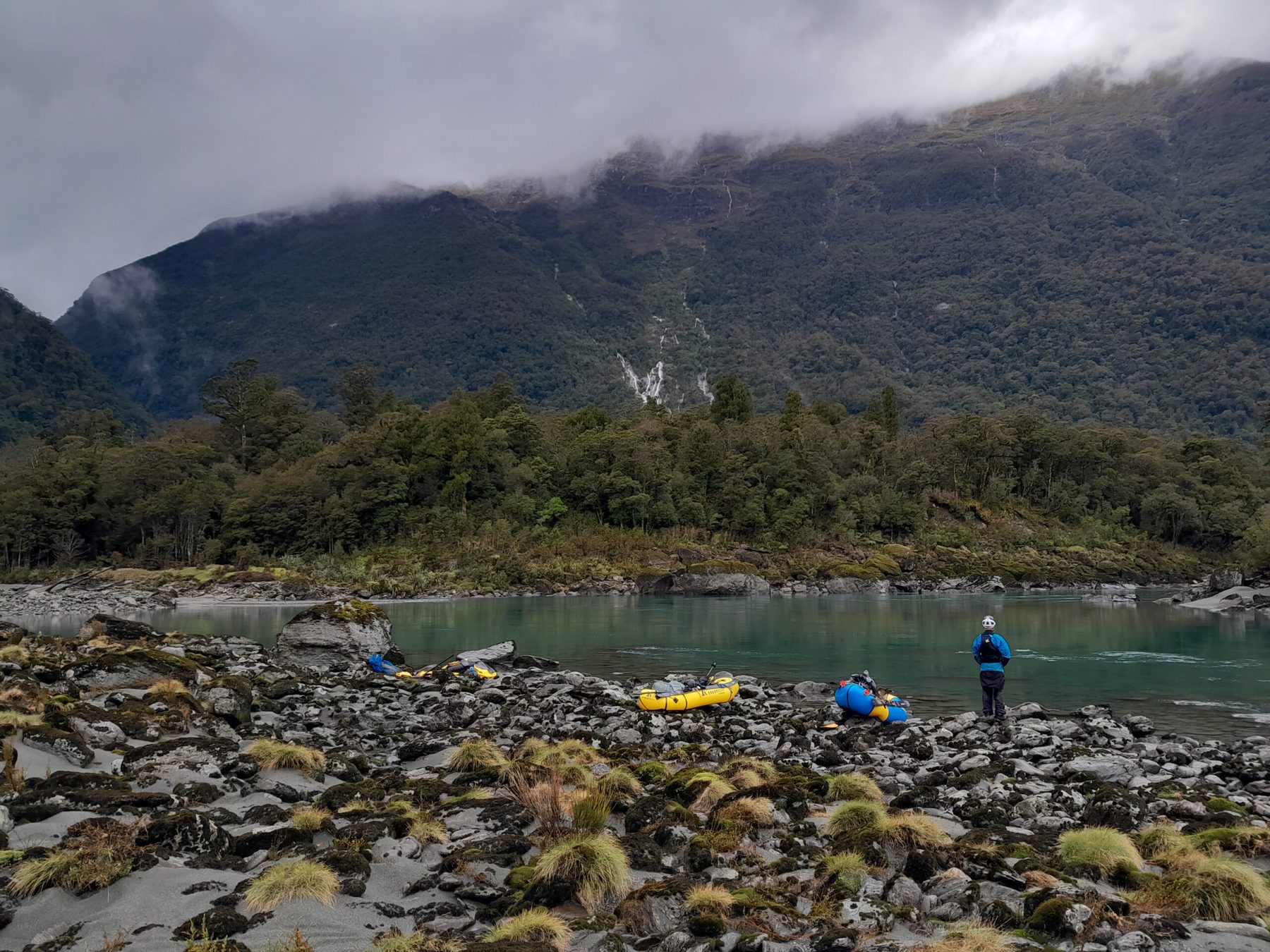
The next morning they packrafted across a beautiful source lake, then came some horrid bush-bashing with skis and packrafts on their backs, really slow and demoralising, and steep riverbed travel down to Bonar Flat, where the wilderness zone ends and packrafting trips usually start.
Reaching Bonar Flat was a big moment of relief. They could blow up the packrafts, get the weight off their backs and use the river. The top section was awesome paddling, and they worked out the harder rapids as a team. They portaged around the main section of rapids, which with all their weight was the safe way to manage it. They camped near Caseys Flats, and with a big rain and snow event coming in, made their way out the next morning to the Waiatoto estuary and paddled out to the ocean. The river was technical, really fun, with some really cool white water.
I asked Nick whether a packraft is harder than a whitewater kayak on rapids like that. For a trained whitewater kayaker, a hard-shell kayak is easier. Packrafts are forgiving for intermediates, but harder and more dangerous for pushing technical white water, so it's about the right craft and skills.
Heavy packs, half a paddle and Nick's advice
The trip took seven days all up. Pack weight was a recurring debate: they never weighed them, and might not have gone if they had. When Nick was struggling, one of his mates carried two packrafts at times.
The weather was a constant unknown. They also had one mishap: a paddle blade got lost, so one of them paddled out the whole Waiatoto with half a paddle.
I reckon that turned a packraft into a canoe.
Nick's advice for anyone planning an expedition like this starts with you:
"your biggest kind of thing to think about is really building your body your skills beforehand and a really versatile skill set so you can deal with whatever is thrown at you"
That way, worse weather and things breaking become less stressful. If you don't need everything to be perfect to keep going, you've got a much bigger safety margin.
For planning, satellite imagery has got a lot better, and it's massive where topo maps aren't correct. New Zealand also has really good trip reports, online, in FMC magazines and in the Alpine Club journals. And use your networks and mentors: ask people for advice.
Next, Nick has a few ideas around the Southern Alps and Fiordland, with lots of options for creative link-ups of different sports. In the shorter term, he's heading to Canada to take a similar approach in the Coast Mountains and Alaska.
Places from this episode
- Mount Aspiring
- Waiatoto River
- Tasman Sea
- Wānaka
- Olivine Wilderness Area
- Volta Glacier
- Therma Glacier
- Matukituki Valley
- Raspberry Flat
- Cascade Hut
- French Ridge
- Quarterdeck
- Bonar Glacier
- Colin Todd Hut
- Bonar Flat
- Caseys Flats
- Alex Knob
Follow Nick
Nick shares his adventures on Instagram, and recommends his two mates' socials too, especially for the photos from this trip.
Links from this episode
- Follow Nick on Instagram: instagram.com/njpascoe/
- Follow Jasper on Instagram: instagram.com/jasper.gibson/
- Follow Charlie on Instagram: instagram.com/murraycharles/
- Follow Abigail on Instagram: instagram.com/abigailhannnah
- Follow Aotearoa Adventures on Instagram: instagram.com/aotearoa_adventures_
More like this
- First-Time Packraft Adventures and Hiking to Lake Crucible with Charlotte
- Five days on the Sladden Glacier climbing Mt Sealy and Mt Jeanette with Kaleb Anderson
- Two NZ Epics - Bicycle Circumnavigation and Packraft Traverse with Dunc Wilson
- First Ascents on Mount Lindenfeld and Mount Haast with Justin Wimmer
Until then, keep adventuring :)
The ultimate
NZ road trip adventure guide
Packed with insider tips and stunning photography, this is the only resource you need to plan your journey.