
Spotify Apple Podcasts Everywhere else Download
Taranaki is such a good region, and I was so excited for this chat. We could have talked about the mountain for hours. So I kept us to the Pouakai Circuit first, then let it wander (it wandered).
Kristina is an outdoor enthusiast based in Auckland, with a bit of photography on the side and a serious hiking habit. She's done most of the tracks on Taranaki, and she walked the Pouakai Circuit in the opposite direction to me, in winter, when I'd done it at Easter. So we compare notes, day by day. Her knees hated one half, I hated the other. And we both had feelings about the tarns.
Then we get into Syme Hut in winter (crampons, ice axe and a lot of stairs), the summit, and the detour dilemma every slow hiker knows. Plus Kristina's hike-planning spreadsheet. Yes, a whole spreadsheet, with a tab for every trip. I'm the opposite, as you'll find out.
In this episode
- From Switzerland to the Pinnacles
- Tongariro in the rain and weekend hiking
- Planning a hike with a spreadsheet
- Tracks on Taranaki
- Pouakai Circuit clockwise from North Egmont
- Pouakai Circuit anticlockwise at Easter
- Pouakai Tarns, gear and side trips
- Syme Hut in winter
- Bucket list: Mitre Peak
From Switzerland to the Pinnacles
Kristina was born in Switzerland and grew up doing a lot of travelling. The family went back almost every second year, to Switzerland or nearby Germany and Austria, and they were often in California too. It was mostly the same places, because that's where family was.
When family visited New Zealand, they'd take them out on walks to all the touristy, scenic spots around Auckland and the North Island, and Kristina got really into photographing them (and posting on Facebook, as you do). Growing up here, it's easy to take it for granted: she never went to the South Island in any way she remembers.
We only did our first South Island trip two years before we recorded, so it happens.
She didn't get into hiking until her last year of university. A super outdoorsy friend had a free weekend and planned to do the Pinnacles in the Coromandel, and asked if she wanted to come. Kristina had never done an overnight hike, so she said yes.
"Absolutely loved it … it was the best experience ever and I've kind of been addicted"
Tongariro in the rain and weekend hiking
Once she'd finished uni and had a job, she suddenly had all these free weekends, and started researching where she could go.
Next up was the Tongariro Alpine Crossing, on Christmas Eve. It rained, it was miserable and they couldn't see a thing. Kristina loved it, and she has so many good memories from that trip, including a couple of photos of them looking like drowned rats. Her husband, her boyfriend at the time, still calls it the worst trip ever: he walked all day, couldn't see a thing, had no idea what he was looking at and got drenched. Same day, completely different memories.
Fitting adventures around work
Kristina is a product manager for a tech company, working fully remotely since COVID, which gives her a lot of flexibility. She's slowly mastering the art of annual leave. She'll take a Friday off here and there to make long weekends, which spreads her time off through the year and makes it feel like more.
It also means she can plan around the weather. Whenever she's taken two weeks off in one go, it has invariably rained the whole time.
With a hike planned, she's happy to get up in the middle of the night for a sunrise, and the planning itself gets her motivated.
Planning a hike with a spreadsheet
Kristina is absolutely a planner. She has a spreadsheet listing all the New Zealand hikes she'd like to do, and every time she plans one, she opens a new tab and writes down everything about it. She finds it therapeutic, and gets almost as much enjoyment out of planning a hike as doing it.
After work she'll sit at her computer and plan a trip:
- DOC websites for the huts, how long it will take, the drive and the weather.
- Instagram, to see other people's photos of the spot and where the sun will be.
- Google Earth, for a look at the lie of the land.
Her favourite part, in her words:
"hop on Instagram type in the location have a look at everybody else's photos look at where the sun is going to be go on Google earth have a look."
Check the time of year too. Kristina has been caught out with a perfect shot planned and the sun in a completely different spot, because it was the wrong season.
I'd never thought of checking other people's photos for the sun, and I'm definitely using that one. Because I am absolutely the opposite. The weekend before we recorded, a girlfriend and I went to do Mount Karioi near Raglan. I had no idea how long it would take, put the mountain into Google Maps, and it dropped us on the wrong side, so we drove 40 minutes round to the other side to start. Beautiful road, no regrets.
It had ropes and chains over mud and dirt, and it was tough. I was really tempted to turn around. Usually Isaac makes me keep going, so I had to motivate myself, and an older couple coming down did the trick. If they could do it, so could I.
Kristina gets that. On one South Island hike, a little old lady with a pack the size of her went past while Kristina was panting, and told her it's all about the breathing. If she could do it, Kristina could get up that hill.
Tracks on Taranaki
Taranaki is one of Kristina's favourite places, and she's done most of the tracks on the mountain.
- Pouakai Circuit. One of her favourites, and up there with the best.
- Mangorei Track. The short version, which takes you to the Pouakai Tarns. Kristina isn't a fan of the boardwalk all the way: she finds the boards spaced a bit too far apart, which annoys her. It's much easier for beginners now, though, and it's a beautiful track through the Goblin Forest.
- Syme Hut. On Fanthams Peak, on the other side of the mountain, and one of her favourites (more below).
- Around the Mountain. Not done yet, because she hasn't had enough time off, and it's on her bucket list. She did take the detour to Lake Dive.
The park is bigger than you'd think. The first time I went, from New Plymouth, I assumed Dawson Falls and North Egmont would be right next to each other. They are not.
Kristina was surprised too: it's about an hour's drive between the two. Tracks start from the North Egmont Visitor Centre and the Mangorei car park, among others.
Pouakai Circuit clockwise from North Egmont
Kristina did the circuit on a long weekend in June, one of the times she didn't plan far ahead. They looked at where the weather would be good in the North Island, checked the spreadsheet, drove down on the Friday night and started early on the Saturday, to do the circuit in two days.
And they lucked out: they could see the mountain the whole time. In her words:
"it's definitely a weather dependent hike. It's much better when you can see the mountain the whole time."
Taranaki is known for being a shy mountain, so it takes a bit of luck, and a good look at the forecast.
Day one: North Egmont to Pouakai Hut
From North Egmont they went up first, on the Holly Hut Track, which heads up towards the mountain on a fairly gradual incline. In June there was snow on that top section, so it was slippery in places. It wasn't boardwalked when she did it, just open track.
From there it drops down to Holly Hut. Kristina had planned to stay there if the day was taking too long, but they got there early and kept going, on to Pouakai Hut.
The stretch between the two huts is short, so I'm not sure a three-day version staying at Holly Hut is worth it.
Between Holly Hut and Pouakai Hut there are a lot of stairs, and it was icy when they did it, with those long, awkward steps where you take two steps for every one. That section took them ages, mostly because they kept stopping for photos: stairs going down with the mountain behind was the ideal shot. Kristina kept looking at the map thinking the hut was really close. It wasn't.
When they went, Pouakai Hut wasn't bookable, so you could rock up and stay. It was completely full, and they had to cram in.
Day two: Pouakai Hut to North Egmont
On day two they walked from Pouakai Hut back out to North Egmont, over a peak with amazing views, then a super steep descent. Kristina regretted doing it that way round. Going downhill was really hard on her knees. When she did it there were no stairs on that section, just roots and mud, very slippery, with a couple of metal sets of stairs. It took a while for her knees to recover.
A front was coming in, so they hurried out. They'd been driving for about an hour when the rain hit.
Pouakai Circuit anticlockwise at Easter
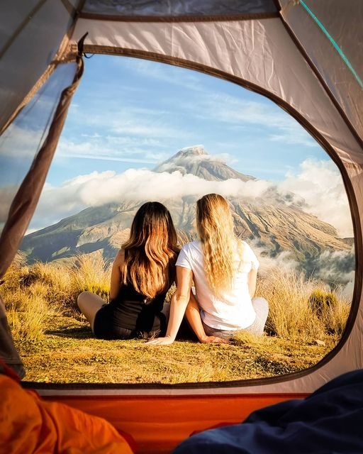
I started at North Egmont as well and went the other way, anticlockwise, at Easter. There was no snow on the mountain. We took a tent, because I really wanted to camp with the mountain view (I'm pretty sure I saw Kristina's photo of it and decided we were carrying a tent). And because we're spontaneous, we didn't book anything: we looked where the sun was shining and went.
The track had just been widened, and I remember the climb being really really steep, with a lot of breaks. Then you've gained all that height and there are steep ladders down the other side.
The plan was two days, with a contingency: if I needed an out, we could walk down the Mangorei Track, and friends in the region could pick us up. You can do it as the Pouakai Crossing or as the circuit.
Day one ended past the tarns, and it was long. I was so over it. It was super windy, there were heaps of people, and the old boardwalk was ripped up for the new one, so we were jumping across planks with packs on. I looked at the tarn and called it a pathetic little lake.
Day two started with the descent from Pouakai Hut to Holly Hut, steeper than I expected, with lots of awkwardly spaced stairs. I was pretty grumpy. Then we crossed the valley facing Taranaki as the clouds cleared, walking on the mountain for the rest of the day, and it was all very pretty. After the valley it's a gradual incline, which I was not keen on.
Pouakai Tarns, gear and side trips
The tarns at sunrise and sunset
Kristina was disappointed too. You see photos of what looks like a massive lake with the mountain behind, and you get there and it's a puddle. It's still worth it, though.
Sunrise and sunset are the best times to see the tarns. During the day there are a lot of people. Both times Kristina went, she stayed for sunset and the next sunrise, and there were only one or two others setting up cameras for long exposures. The second time, she camped at the top, which she rates way better than staying in the hut.
What to pack
Your standard overnight essentials, whether you're camping or in the hut. In June it got quite cold, so add:
- Extra thermals and a beanie.
- Gloves. Kristina keeps forgetting hers and regrets it every time, because she gets really cold hands. Don't forget your gloves.
- Hiking poles. She didn't take any, and would have liked them for the downhill. Poles help distribute your weight, so your back and legs are less sore, and she goes a bit faster with them. As a slow hiker, any extra speed helps.
The upside of June: far fewer people on the track, and snow on that top section.
Side trips and the detour dilemma
From Holly Hut there's a side trip to a waterfall. Kristina skipped it: the one other person at the hut said it wasn't worth it, then later someone told her it was really cool and they'd had lunch there. Next time she'd stop. From Pouakai Hut there's a short side trip up one of the peaks, which she's heard has a pretty nice view if you can see the mountain. She hasn't done that one either.
This is my constant dilemma. There's always a little detour, ten or fifteen minutes off the track, and I don't want to do any extra walking. Then I get home and recover and think, it was ten minutes. Now I'd have to walk for hours to get back to it.
Kristina's the opposite. On Lake Waikaremoana she did every single detour, because she didn't want to have to do the whole thing again for one waterfall. She regretted that enthusiasm when they arrived at half past eleven at night. Her head torch had died, so she was using her phone. It was summer, so it wasn't cold, and leaving earlier in the day would have fixed it.
Syme Hut in winter
Syme Hut is one of Kristina's favourite winter hikes ever. She hates scree and avoids it at all costs, which is why she does a lot of winter hiking.
It's quite technical in winter. You need experience with crampons and an ice axe, and you need to know how to self-arrest, because snow falls, melts and turns into ice, and the slope gets super steep. Kristina was surprised how steep it was, and it took longer than she expected while she took her time making sure of her footing. The good thing is there are no cliff edges to worry about: if you slip and know how to self-arrest, it's one straight slope.
Be prepared for so many stairs. From the car park to the snowline it's stairs, stairs and more stairs, with an overnight pack and sore legs. Just before the snowline there's the turnoff to Lake Dive, which goes around the side, and the way up to Syme Hut.
She did it with her husband, and she wouldn't do a technical winter climb on her own. Having someone there means support, someone to complain to when your legs are sore and, if something happens, safety.
The views from the top, with the sun dancing off the ice crystals, were her highlight. They stayed the night in the hut, the sunrise was amazing, and they had really good weather again. Kristina loves how far you can see on a clear day.
You can see as far as Ruapehu and Tongariro from up there, and some of my favourite New Zealand photos are from Syme Hut in winter. It's on my bucket list, though not too high, because I need more winter experience, and I'm not a fan of scree either.
And the coolest thing Kristina has seen: a guy who carried his snowboard all the way up, stayed in the hut, then snowboarded down. He waved on his way past.
If anyone knows who he is, please send me a message, because I need him on the podcast.
The summit
Kristina hasn't done Syme Hut in summer, because the idea of the scree puts her off. She has done the Taranaki summit, on a route with a lot of scree. It was okay going up, and coming down the steep scree she fell over so many times.
The route most people take to the summit is marked with poles, which makes it the easier way up. The good thing about Taranaki is that it's quite straight up and down. Unlike Ruapehu, with its ridges and valleys where you can get lost, you can see the top as you go.
On that Mount Karioi hike, I spotted a little triangle of white snow on the horizon. Cloud or Taranaki? We'll say Taranaki.
Bucket list: Mitre Peak
Kristina's bucket list is a whole spreadsheet, so picking one was hard. Her number one for now is climbing Mitre Peak in Milford Sound. It's out of her league at the moment, and she needs to get a bit fitter, but she's obsessed with people's YouTube videos of it. She loves that you have to kayak to it, and that you can bivvy halfway up before the summit. The views from the top look insane.
She's a bit addicted to climbing mountains now: she's done most of the North Island peaks and is starting on the South Island ones. She'll have to move down there at some point, though the South Island doesn't have Taranaki.
Places from this episode
- Pinnacles
- Coromandel
- Tongariro Alpine Crossing
- Mount Karioi
- Raglan
- Taranaki
- Pouakai Circuit
- Mangorei Track
- Goblin Forest
- Pouakai Tarns
- North Egmont Visitor Centre
- Holly Hut
- Pouakai Hut
- Syme Hut
- Fanthams Peak
- Around the Mountain
- Lake Dive
- Dawson Falls
- New Plymouth
- Lake Waikaremoana
- Ruapehu
- Mitre Peak
- Milford Sound
Follow Kristina
Kristina shares her photos, tips from her adventures and places to visit on Instagram, and she's just started on TikTok.
Links from this episode
- Follow Kristina on Instagram: instagram.com/kristinamonts
- Follow Kristina on TikTok: tiktok.com/@kristinamonts
- Follow Abigail on Instagram: instagram.com/abigailhannnah
- Follow Aotearoa Adventures on Instagram: instagram.com/aotearoa_adventures_
More like this
- Hiking to Barker Hut and Ranking NZ's Best DOC Huts with Chris Lierheimer
- Solo Tramping the Mangamate Loop in Whirinaki Forest Park with Sharon Evans
- Tramping the Canyon Creek Track as a Beginner with Debbie Cartwright
- Exploring the Nelson Lakes National Park with Mel White
Until then, keep adventuring :)
The ultimate
NZ road trip adventure guide
Packed with insider tips and stunning photography, this is the only resource you need to plan your journey.