Spotify Apple Podcasts Everywhere else Download
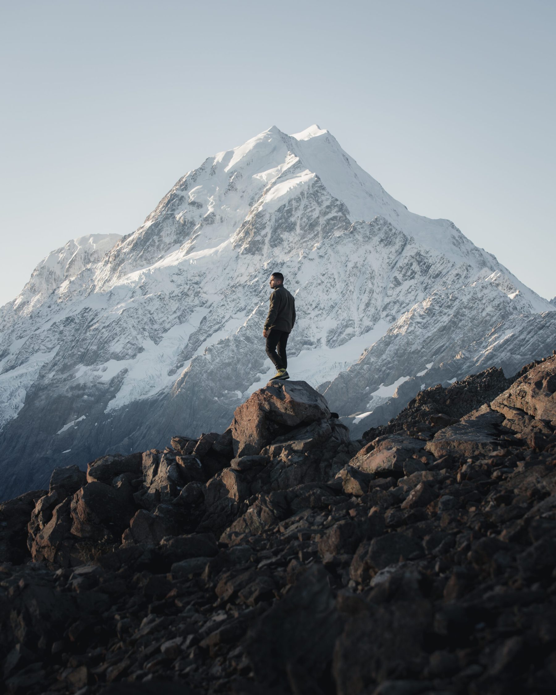
I had to Google Mount Wakefield before this chat. And then I couldn't stop looking at it.
Jinal is a Wellington photographer, born and bred, who shoots weddings and couples, creates content for outdoor and travel brands and co-hosts adventure photography workshops. And when he's not doing any of that, he's out exploring. He suggested we talk about Mount Wakefield, an unmarked ridgeline in Aoraki Mount Cook National Park that most people drive straight past on the way to the Hooker Valley.
So we get into the whole trip: the plan, the routefinding (so so much routefinding), his very first night in a bivvy bag and why they turned around at the summit. Then his favourite tips for outdoor photos, how he handles a fear of heights while loving mountains, and his advice for anyone who wants to get outside more.
In this episode
- How Jinal got into the outdoors
- Belmont Regional Park, his Wellington backyard
- Mount Wakefield in Aoraki Mount Cook National Park
- Routefinding off track with Topo maps
- His first night in a bivvy
- Aoraki, Mueller Hut and mountaineering
- Adventure photography tips
- Fear of heights and getting out there
How Jinal got into the outdoors
Jinal has always been active, playing hockey and tennis and doing a bit of running. As a kid he was always outside, mingling with the neighbours' kids and exploring the backyard, so he's always had an appreciation for the outdoors. Hiking and camping weren't part of growing up, though. Mountain biking was about it.
Travel came later, on a trip to Southeast Asia with friends. That's when he fell in love with getting somewhere new and learning about the culture, the outdoors and nature. Photography grew out of that, and so did hiking.
Summer wedding season is hectic, and he's often struggled to find time to get out then. The beauty of his work is that weddings happen all over the country, so he adds an adventure into a work trip whenever he can. Work and play.
Even so, he has to sit down and plan a trip in between, for that work-life balance. Getting out is a mental reset for him. When you work for yourself you're always switched on, so he has to tell himself to enjoy what's around him and be present, and let the next task and the emails wait.
Belmont Regional Park, his Wellington backyard
Jinal lives near Belmont Regional Park, about half an hour out of the city centre. It's a massive place to hike and mountain bike. He's spent a lot of time mountain biking there, and these days he goes out for trail runs. It's his backyard.
My Wellington trip was almost a year before we recorded, and I was shown some of the gems around Upper Hutt. Jinal rates it too, because it's close to plenty more to explore. Having lived in Wellington his whole life, he says you lose your appreciation for it a bit.
Mount Wakefield in Aoraki Mount Cook National Park
Mount Wakefield is in Aoraki Mount Cook National Park, and Jinal reckons it's more unknown because everyone's used to the Hooker Valley, Mueller Hut and the Tasman Glacier. It's the ridgeline you see between Hooker Lake and Tasman Lake, on your right as you drive into the national park.
He went in May with three friends. It's unmarked, so it's quite challenging. It starts at a corner of the road down to Tasman Lake. For the first couple of hundred metres you're in the bushline, then it gets straight into elevation and opens out, and you're on an exposed ridgeline for most of it. In winter it would have snow on it. When they went, it was all scree.
The plan
The original plan was Mount Wakefield, then down and out via Tasman Lake, almost two days. They packed enough food, water and gear to bivvy for two nights. They'd reach the summit for sunset, set up camp, and carry on the next morning.
The routefinding took a lot longer than they expected, so they didn't make the summit for sunset. They bivvied that night, and sitting at camp, decided they wouldn't traverse right through.
Summit morning
It's super cold in the alpine overnight, and by morning the rocks had iced over. So they waited for the sun to come up and warm the rocks before heading for the summit, leaving most of their gear at the bivvy.
Even then, the last section was a scramble up scree and ice. They were prepared, but at the top they all agreed that was it. Clambering through ice with heavy packs, waiting for the day to heat up, on short May days, after how long the routefinding had taken: it wasn't going to work. So they went back to camp, packed up and walked out the way they came.
Going down was easier. They knew the way, they were blessed with good weather, and a friend's watch had mapped their route up, so they could follow it back.
The views
Once you're up on that ridgeline, you've got 360-degree views the entire way. You look down into Tasman Lake and Hooker Lake, across to Mount Sefton and Aoraki, back towards Mueller Hut, and all the way down to Lake Pukaki and Tekapo.
Jinal has walked the Hooker Valley so many times that it was special to see it from above, from a spot so few people go.
Routefinding off track with Topo maps
Jinal says he's not amazing at routefinding, so he goes with very experienced people. Before Wakefield they researched: a photographer who'd been up a few weeks earlier shared a map of his route, and they used the Topo maps app.
Once you're up there, you're finding the safest way to where you want to go. You can roughly see a way up, but it's all scree, so it takes decision making. On Mount Wakefield, staying a bit lower than the ridgeline is a lot safer, because the other side is basically a sheer drop. So they didn't go over every summit along the ridge, and bee-lined it a bit lower.
At one point all four of them stopped and asked where to go, and sat there a while working out the best way around. With heavy packs on scree (one step up, two steps back), you don't want to wander off, then have to backtrack and try a different route. Good fun, though.
How he uses the Topo app
He has the app on his phone, with the North Island and South Island maps. It works offline, using GPS to show where you are, and from there you need to know how to read a topo map. He has pretty basic knowledge, enough to get him around: the lines show how steep or far something is, so you can tell if one way down will be a lot steeper.
Most marked tracks are preloaded, and a compass line shows you where to look, so in low visibility you can get back on track. It's the unmarked routes where you have to figure it out.
I got the South Island Topo maps on a road trip almost a year before we recorded, and they're helpful even when you're driving through patches with no data. Since then I've got the North Island one too. My problem is that I check it every two hundred metres to see if I'm there yet. Jinal is the same, especially when he's with people who are a lot quicker than him.
I haven't done any off-track tramping myself, so this was all new to me.
His first night in a bivvy
Wakefield was Jinal's first time bivvying, and he didn't like it, though he feels he needs to do it again. A bivvy is lighter than a tent, and you can whip it out and stay wherever.
Hers had nothing to hold the cover off your face, so it tied up to a hiking pole. In the night he knocked the pole over, so condensation gave him a wet face the whole night.
The beauty of it is opening it up and looking out at the stars. In his words:
"you're just laying there in a bag on a mountain looking at stars"
It wasn't winter cold, and they had no wind the entire trip, with clear blue skies and a night full of stars. That was planned: they'd looked for a weather window, because in the alpine they didn't want to be caught out in a storm, away from a hut. Luckily, the weather played ball.
I've been so lucky. Every time I've been to Aoraki I've had blue skies and could see the mountain.
Aoraki, Mueller Hut and mountaineering
Aoraki Mount Cook is one of Jinal's favourite places in the whole country. The drive into the national park, the first sight of Aoraki and Lake Pukaki:
"It never gets old. You know it just never does"
It's the sheer size of Aoraki and the surrounding mountains, he says, almost a spiritual connection with the place. It's his happy place.
What blows my mind most is that from Hooker Lake, it feels like you've walked right up to it. There aren't many places in the world where you can walk to the foothills of the tallest mountain in the country. Where I grew up in India, the Himalayas are layer on layer on layer.
Most of Jinal's mountaineering has been on Ruapehu and Taranaki. In Aoraki Mount Cook National Park, one of his workshops went up to Mueller Hut in April. It wasn't meant to snow, but it did, overnight, and they had snow from about halfway. It was fresh and soft, so they didn't need their crampons or ice axes. Mueller was awesome.
Adventure photography tips
The workshops Jinal co-hosts focus on adventure and outdoor photography: capturing what's around you and telling a story with it. They cover composition, lighting, camera skills and editing, plus how to work with brands.
His tips:
- Light is the biggest thing. Wake up early and be there for sunrise, or go up for sunset. A lot of outdoor lovers hike in the middle of the day, and the way a place transforms at sunrise or sunset is so dramatic.
- Look around you. On a classic spot like Roys Peak, look beyond the classic hero shot at what's around you and what's changing.
- Add a human element. A person in the landscape tells the story, and it gives scale, which works really well with mountains.
As he explains it:
"It also connects a viewer you know like for yourself if you're looking an image and you see a person and then you see the landscape. You're kind of connected to that person"
Does he ever put the camera down? It's half and half. When there's a banger of a sunrise he's running around capturing everything. The other half of the time, he puts the camera down and enjoys what's in front of him, often with friends or people he's just met, sharing stories in an amazing place. Those are the memories we connect to, he says.
Fear of heights and getting out there
Jinal has a fear of heights, and he loves mountains. Getting into mountaineering meant overcoming that fear in alpine environments. The year before we recorded, he also did a big slog that went from bush to glaciers to a bit of rock climbing, and it pushed what he knew about hiking.
Every time he overcomes a bigger mountain, he wants to know what he can do next. Now he wants to do an alpine course and learn the skills to tackle big peaks.
A couple of years ago, my husband got me into rock climbing, and he has a huge fear of heights. I was always amazed he could be twenty metres up the wall. I don't think it was easy for him, but there's some comfort in knowing the safety measures are in place.
Jinal's advice is to get out of your comfort zone. We live such fast-paced lives, so stop, find a local track or a group, and challenge yourself. You might hate hiking, but at least you tried, and most of the time you'll probably love it. For some people a local trail is the big thing, and that counts too. His biggest thing:
"make yourself uncomfortable and get a get out there"
His bucket list keeps growing. He's hoping to move to the South Island, and he hasn't done the Catlins or further south, Abel Tasman further north, or much of Northland.
Mount Wakefield is on my list now too, with someone experienced to lead the way. And talking about places I've been to is fun as well: I had Dylan Arthur on a while ago to talk about Angelus, and I'd done it too.
Places from this episode
- Aoraki Mount Cook National Park
- Mount Wakefield
- Hooker Lake
- Tasman Lake
- Hooker Valley
- Mueller Hut
- Tasman Glacier
- Mount Sefton
- Lake Pukaki
- Tekapo
- Belmont Regional Park
- Upper Hutt
- Ruapehu
- Taranaki
Follow Jinal
Jinal shares his adventure work and workshop news on Instagram under his own name, with his wedding and couples work on a separate photography account.
More like this
- The Frustration and Elation of Landscape Photography with Meghan Maloney
- A Mountaineering Career and Climbing Mt Aspiring with Dom Huxley
- Pioneering Women of Aoraki Mount Cook with Hazel Phillips
- Five days on the Sladden Glacier climbing Mt Sealy and Mt Jeanette with Kaleb Anderson
Until then, keep adventuring :)
The ultimate
NZ road trip adventure guide
Packed with insider tips and stunning photography, this is the only resource you need to plan your journey.